Night club nearby Babalu Bar
Austria
Night club nearby Babalu Bar
Babalu Bar
Ullmannstraße 57, Wien Austria
contacts phone
:
+43
Latitude:
48.1857831
, Longitude:
16.3307445
read more
nearest Night club
331 m
U4 Vienna
Schönbrunner Straße 222-228, Wien
Night club
read more
331 m
TuesdayClub
222-228, Schönbrunner Straße, Wien
Night club
read more
345 m
Tuesday4Club
Schönbrunner Straße 222-228, Wien
Night club
read more
358 m
Mon'Ami Shisha Lounge
Schönbrunner Straße 222-228, Wien
Night club
read more
717 m
Asien Prostituierte
Rechte Wienzeile 247, Wien
Night club
read more
717 m
Studio 247
Rechte Wienzeile 247, Wien
Night club
read more
766 m
UTOPIA
Ruckergasse 30-32, Wien
Night club
read more
919 m
Pub Crawl Vienna
Mariahilfer Gürtel 21, Wien
Night club
read more
950 m
Studio Leila Wien
Ignazgasse 42/d, Wien
Night club
read more
1.022 km
Claudschistan
Sechtergasse 5, Wien
Night club
read more
1.068 km
CLUB 28
Felberstraße 78, Wien
Night club
read more
1.076 km
chb
Fünfhaus, Wien
Night club
read more
1.224 km
ÖBB Lounge: Ihr First Class-Service am Bahnhof
Eichenstraße 25, Wien
Night club
read more
1.514 km
Tangoloft Vienna
Cothmannstraße 9, Wien
Night club
read more
1.525 km
Cream Lounge Vienna
Märzstraße 23, Wien
Night club
read more
1.851 km
Super Unusual Beings
Storkgasse 7, Wien
Night club
read more
1.855 km
PRODZ
Pottendorfer Straße, Wien
Night club
read more
1.928 km
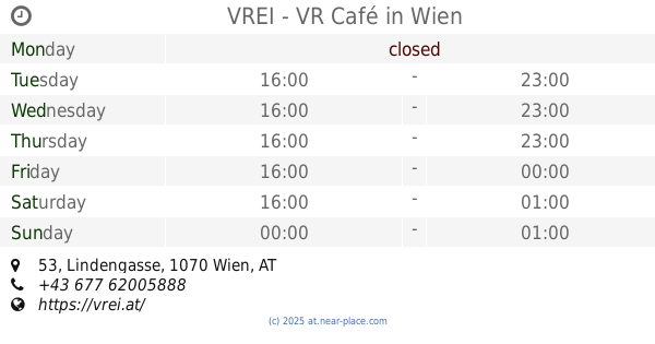
VREI - VR Café
Lindengasse 53, Wien
Night club
read more
1.935 km
Royal Bar & Nightclub
42, Neubaugürtel, Wien
Night club
read more
1.97 km
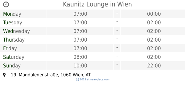
Kaunitz Lounge
Magdalenenstraße 19, Wien
Night club
read more
2.025 km
Camera
Neubaugasse 2, Wien
Night club
read more
2.051 km
STYLEZ
Neubaugasse 10, Wien
Night club
read more
2.194 km
Luftbad
Luftbadgasse 17, Wien
Night club
read more
2.263 km
LMC Vienna
Hamburgerstraße 4, Wien
Night club
read more
2.442 km
Monaco Bar - Nightclub
Lindengasse 4, Wien
Night club
read more
📑
all categories
Accounting
Administrative area level 1
Administrative area level 2
Airport
Amusement park
Aquarium
Art gallery
Atm
Bakery
Bank
Bar
Beauty salon
Bicycle store
Book store
Bowling alley
Bus station
Cafe
Campground
Car dealer
Car rental
Car repair
Car wash
Casino
Cemetery
Church
City hall
Clothing store
Colloquial area
Convenience store
Country
Courthouse
Dentist
Department store
Doctor
Electrician
Electronics store
Embassy
Finance
Fire station
Florist
Food
Funeral home
Furniture store
Gas station
General contractor
Grocery or supermarket
Gym
Hair care
Hardware store
Health
Hindu Temple
Home goods store
Hospital
Insurance agency
Jewelry store
Laundry
Lawyer
Library
Light rail station
Liquor store
Local government office
Locality
Locksmith
Lodging
Meal delivery
Meal takeaway
Mosque
Movie rental
Movie theater
Moving company
Museum
Natural feature
Neighborhood
Night club
Painter
Park
Parking
Pet store
Pharmacy
Physiotherapist
Place of worship
Plumber
Point of interest
Police
Political
Post office
Premise
Real estate agency
Restaurant
Roofing contractor
Route
Rv park, camping
School
Shoe store
Shopping mall
Spa
Stadium
Storage
Store
Subpremise
Subway station
Supermarket
Synagogue
Taxi stand
Train station
Transit station
Travel agency
University
Veterinary care
Zoo
administrative area level 3
sublocality level 1
↑