Night club nearby Claudschistan
Coronavirus disease (COVID-19) Situation
confirmed cases
6081287
deaths
22542
Austria
Night club nearby Claudschistan
Claudschistan
Sechtergasse 5, Wien Austria
contacts phone
:
+43
Latitude:
48.1766526
, Longitude:
16.3323831
read more
nearest Night club
93 m
Studio Leila Wien
Ignazgasse 42/d, Wien
Night club
read more
274 m
ÖBB Lounge: Ihr First Class-Service am Bahnhof
Eichenstraße 25, Wien
Night club
read more
375 m
WG
Erlgasse 38, Wien
Night club
read more
492 m
Tango Mlonga
Cothmannstraße 9, Wien
Night club
read more
492 m
Tangoloft Vienna
Cothmannstraße 9, Wien
Night club
read more
525 m
UTOPIA
Ruckergasse 30-32, Wien
Night club
read more
540 m
No Limits
Wurmbstraße 36, Wien
Night club
read more
540 m
No Limits SM Bar & Lounge
Wurmbstraße 36, Wien
Night club
read more
733 m
Neustift Am Walde Friedhof
Unter-Meidlinger Straße 67, Wien
Night club
read more
790 m
TuesdayClub
222-228, Schönbrunner Straße, Wien
Night club
read more
790 m
U4 Vienna
Schönbrunner Straße 222-228, Wien
Night club
read more
798 m
Tuesday4Club
Schönbrunner Straße 222-228, Wien
Night club
read more
807 m
Mon'Ami Shisha Lounge
Schönbrunner Straße 222-228, Wien
Night club
read more
857 m
PRODZ
Pottendorfer Straße, Wien
Night club
read more
904 m
chb
Fünfhaus, Wien
Night club
read more
1.022 km
Babalu Bar
Ullmannstraße 57, Wien
Night club
read more
1.271 km
Studio 247
Rechte Wienzeile 247, Wien
Night club
read more
1.271 km
Asien Prostituierte
Rechte Wienzeile 247, Wien
Night club
read more
1.729 km
Stiege 12
Andersengasse 31, Wien
Night club
read more
1.774 km
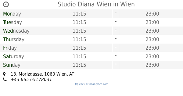
Studio Diana Wien
Morizgasse 13, Wien
Night club
read more
1.815 km
Pub Crawl Vienna
Mariahilfer Gürtel 21, Wien
Night club
read more
1.844 km
Super Unusual Beings
Storkgasse 7, Wien
Night club
read more
1.85 km
SUB
Storkgasse 7, Wien
Night club
read more
2.273 km
Villasandwirt
Sandwirtgasse 9, Wien
Night club
read more
2.297 km
hightechgameshandy
Linzer Straße 59, Wien
Night club
read more
📑
all categories
Accounting
Administrative area level 1
Administrative area level 2
Airport
Amusement park
Aquarium
Art gallery
Atm
Bakery
Bank
Bar
Beauty salon
Bicycle store
Book store
Bowling alley
Bus station
Cafe
Campground
Car dealer
Car rental
Car repair
Car wash
Casino
Cemetery
Church
City hall
Clothing store
Colloquial area
Convenience store
Country
Courthouse
Dentist
Department store
Doctor
Electrician
Electronics store
Embassy
Finance
Fire station
Florist
Food
Funeral home
Furniture store
Gas station
General contractor
Grocery or supermarket
Gym
Hair care
Hardware store
Health
Hindu Temple
Home goods store
Hospital
Insurance agency
Jewelry store
Laundry
Lawyer
Library
Light rail station
Liquor store
Local government office
Locality
Locksmith
Lodging
Meal delivery
Meal takeaway
Mosque
Movie rental
Movie theater
Moving company
Museum
Natural feature
Neighborhood
Night club
Painter
Park
Parking
Pet store
Pharmacy
Physiotherapist
Place of worship
Plumber
Point of interest
Police
Political
Post office
Premise
Real estate agency
Restaurant
Roofing contractor
Route
Rv park, camping
School
Shoe store
Shopping mall
Spa
Stadium
Storage
Store
Subpremise
Subway station
Supermarket
Synagogue
Taxi stand
Train station
Transit station
Travel agency
University
Veterinary care
Zoo
administrative area level 3
sublocality level 1
↑