Supermarket nearby ACTION SHOP
Austria
Supermarket nearby ACTION SHOP
ACTION SHOP
Lichtenegger Straße 184, Wels Austria
contacts phone
:
+43
Latitude:
48.1437626
, Longitude:
13.9728252
read more
nearest Supermarket
179 m
HOFER
Malvenstraße 3, Wels
Supermarket
read more
179 m
HOFER Wels-West
Malvenstraße 3, Wels
Supermarket
read more
214 m
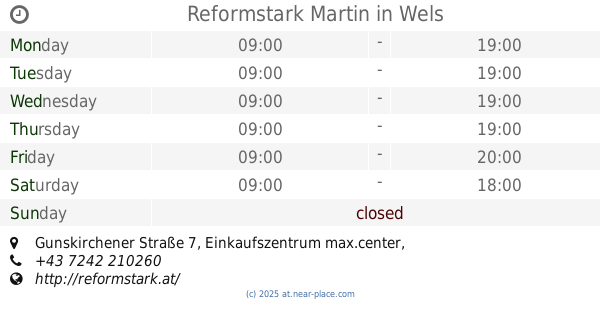
Reformstark Martin
Gunskirchener Straße 7, Einkaufszentrum max.center, Wels
Supermarket
read more
215 m
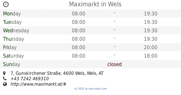
Maximarkt
Gunskirchener Straße 7, Wels
Supermarket
read more
1.275 km
EUROSPAR
Europastraße 60, Wels
Supermarket
read more
1.624 km
NORMA Filiale
Föhrenstraße 20, Wels
Supermarket
read more
1.624 km
Norma
Föhrenstraße 20, Wels
Supermarket
read more
1.824 km
NORMA Filiale
Salzburger Straße 149, Wels
Supermarket
read more
2.398 km
Unimarkt
Lindenstraße 7, Wels
Supermarket
read more
2.398 km
UNIMARKT Handelsgesellschaft m.b.H. & Co. Kommanditgesellschaft
Lindenstraße 7, Wels
Supermarket
read more
2.55 km
Basak GesmbH
Dragonerstraße 72, Wels
Supermarket
read more
2.597 km
HOFER
Wimpassinger Straße 1, Wels
Supermarket
read more
2.597 km
HOFER Wels
Wimpassinger Straße 1, Wels
Supermarket
read more
2.608 km
SPAR Bernhard Poschacher
Pichler Straße 4, Gunskirchen
Supermarket
read more
2.615 km
EUROSPAR
Schmierndorferstraße 35, Wels
Supermarket
read more
2.835 km
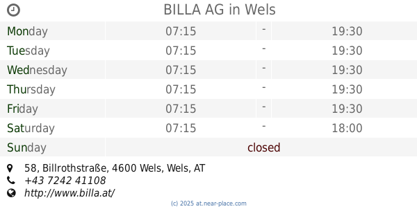
BILLA AG
Billrothstraße 58, Wels
Supermarket
read more
2.85 km
DHL-Abholung Packet Dienst.
Billrothstraße 58, Wels
Supermarket
read more
2.884 km
BILLA
Maria-Theresia-Straße 55, Wels
Supermarket
read more
2.885 km
BILLA AG
Maria-Theresia-Straße 55, Wels
Supermarket
read more
2.886 km
DHL-Abholung Paket Dienst
Maria-Theresia-Straße 55, Wels
Supermarket
read more
2.927 km
BILLA AG
Dahlienstraße 2, Gunskirchen
Supermarket
read more
3.231 km
SPAR
Römerstraße 148, Wels
Supermarket
read more
3.58 km
HOFER Wels
Römerstraße 142, Wels
Supermarket
read more
3.58 km
HOFER
Römerstraße 142, Wels
Supermarket
read more
3.746 km
PENNY Markt
Eiselbergstraße 4, Wels
Supermarket
read more
📑
all categories
Accounting
Administrative area level 1
Administrative area level 2
Airport
Amusement park
Aquarium
Art gallery
Atm
Bakery
Bank
Bar
Beauty salon
Bicycle store
Book store
Bowling alley
Bus station
Cafe
Campground
Car dealer
Car rental
Car repair
Car wash
Casino
Cemetery
Church
City hall
Clothing store
Colloquial area
Convenience store
Country
Courthouse
Dentist
Department store
Doctor
Electrician
Electronics store
Embassy
Finance
Fire station
Florist
Food
Funeral home
Furniture store
Gas station
General contractor
Grocery or supermarket
Gym
Hair care
Hardware store
Health
Hindu Temple
Home goods store
Hospital
Insurance agency
Jewelry store
Laundry
Lawyer
Library
Light rail station
Liquor store
Local government office
Locality
Locksmith
Lodging
Meal delivery
Meal takeaway
Mosque
Movie rental
Movie theater
Moving company
Museum
Natural feature
Neighborhood
Night club
Painter
Park
Parking
Pet store
Pharmacy
Physiotherapist
Place of worship
Plumber
Point of interest
Police
Political
Post office
Premise
Real estate agency
Restaurant
Roofing contractor
Route
Rv park, camping
School
Shoe store
Shopping mall
Spa
Stadium
Storage
Store
Subpremise
Subway station
Supermarket
Synagogue
Taxi stand
Train station
Transit station
Travel agency
University
Veterinary care
Zoo
administrative area level 3
sublocality level 1
↑