Supermarket nearby Denner
Austria
Supermarket nearby Denner
Denner
Stossstrasse 2, Altstätten Österreich
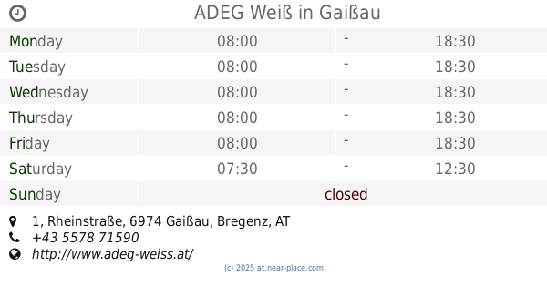
contacts phone
:
+43
Latitude:
47.3771825
, Longitude:
9.5376993
read more
nearest Supermarket
15 m
Migros
Stossstrasse 2, Altstätten
Supermarket
read more
864 m
Coop
Rorschacherstrasse 34, Altstätten
Supermarket
read more
1.979 km
ALDI Altstätten
Oberrieterstrasse 85, Altstätten
Supermarket
read more
2.105 km
Lidl Schweiz
Im Gehrenhof 2, Lüchingen
Supermarket
read more
3.909 km
Migros Partner
Staatsstrasse 128, Rebstein
Supermarket
read more
3.927 km
Altag Detailhandels AG Rebster Markt
Staatsstrasse 128, Rebstein
Supermarket
read more
4.127 km
VOLG Rebstein
Bahnhofstrasse 37, Rebstein
Supermarket
read more
5.512 km
Denner Satellit
Konsumgenossenschaft
Supermarket
read more
7.4 km
Coop Supermarkt Heiden
Rosentalstrasse 2, Heiden
Supermarket
read more
9.231 km
Sutterlüty Ländlemarkt
Dr. Alfons Heinzlestrasse 41, Götzis
Supermarket
read more
9.493 km
Lidl
Im Buch 47, Götzis
Supermarket
read more
9.585 km
HOFER Götzis
Im Buch 40, Götzis
Supermarket
read more
9.585 km
HOFER
Im Buch 40, Götzis
Supermarket
read more
10.645 km
ADEG Weiß
Rheinstraße 1, Gaißau
Supermarket
read more
11.473 km
Adeg Neumann
Treietstraße 17, Klaus
Supermarket
read more
13.178 km
INTERSPAR
Altenstadt AT, Königshofstraße 79, Feldkirch
Supermarket
read more
13.579 km
SPAR
Rheinstrasse 54, Feldkirch
Supermarket
read more
13.88 km
Sutterlüty Ländlemarkt
Stiegstraße 44, Rankweil
Supermarket
read more
14.22 km
SPAR
Alemannenstraße 20, Rankweil
Supermarket
read more
14.586 km
Lidl
Lustenauer Straße 46, Dornbirn
Supermarket
read more
14.586 km
Lidl Österreich GmbH
Lustenauer Straße 46, Dornbirn
Supermarket
read more
15.372 km
Sutterlüty Ländlemarkt
Rheinstraße 99b, Hard
Supermarket
read more
15.478 km
SPAR
Reichsstraße 137, Feldkirch
Supermarket
read more
17.845 km
SPAR
Schäfferhofstraße 1, Hard
Supermarket
read more
18.201 km
SPAR Bäckeri Hutter
Bundesstraße 58, Lauterach
Supermarket
read more
📑
all categories
Accounting
Administrative area level 1
Administrative area level 2
Airport
Amusement park
Aquarium
Art gallery
Atm
Bakery
Bank
Bar
Beauty salon
Bicycle store
Book store
Bowling alley
Bus station
Cafe
Campground
Car dealer
Car rental
Car repair
Car wash
Casino
Cemetery
Church
City hall
Clothing store
Colloquial area
Convenience store
Country
Courthouse
Dentist
Department store
Doctor
Electrician
Electronics store
Embassy
Finance
Fire station
Florist
Food
Funeral home
Furniture store
Gas station
General contractor
Grocery or supermarket
Gym
Hair care
Hardware store
Health
Hindu Temple
Home goods store
Hospital
Insurance agency
Jewelry store
Laundry
Lawyer
Library
Light rail station
Liquor store
Local government office
Locality
Locksmith
Lodging
Meal delivery
Meal takeaway
Mosque
Movie rental
Movie theater
Moving company
Museum
Natural feature
Neighborhood
Night club
Painter
Park
Parking
Pet store
Pharmacy
Physiotherapist
Place of worship
Plumber
Point of interest
Police
Political
Post office
Premise
Real estate agency
Restaurant
Roofing contractor
Route
Rv park, camping
School
Shoe store
Shopping mall
Spa
Stadium
Storage
Store
Subpremise
Subway station
Supermarket
Synagogue
Taxi stand
Train station
Transit station
Travel agency
University
Veterinary care
Zoo
administrative area level 3
sublocality level 1
↑