Cafe nearby Pauluscafe Konditorei Murauer
Austria
Cafe nearby Pauluscafe Konditorei Murauer
Pauluscafe Konditorei Murauer
Reichenauer Straße 68, Innsbruck Österreich
contacts phone
:
+43
Latitude:
47.2726314
, Longitude:
11.4164509
read more
nearest Cafe
282 m
Reichenauerstüberl
Wörndlestraße 19, Innsbruck
Cafe
read more
374 m
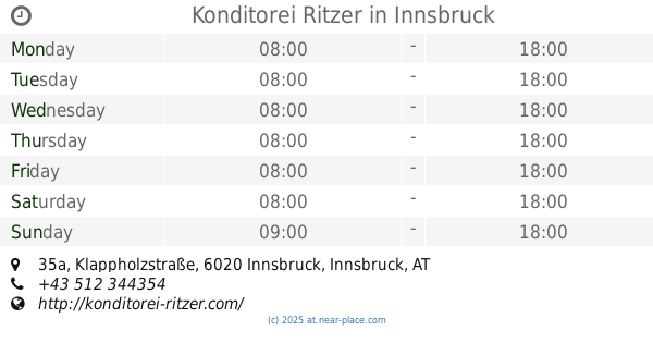
Konditorei Ritzer
Klappholzstraße 35a, Innsbruck
Cafe
read more
401 m
Sportcafe
Klappholzstraße 2, Innsbruck
Cafe
read more
506 m
Cafe-Pub Black-Horse
Andechsstraße 44, Innsbruck
Cafe
read more
509 m
Cafe Top Spin
Radetzkystraße 41, Innsbruck
Cafe
read more
646 m
Promenade Café
Reichenauer Straße 123, Innsbruck
Cafe
read more
682 m
Cafe Andreas Stüberl
Ingenieur-Etzel-Straße 78, Innsbruck
Cafe
read more
788 m
Cafe Bodega
48, Gumppstraße, Innsbruck
Cafe
read more
795 m
Karoline Bliem
Gumppstraße 48, Innsbruck
Cafe
read more
909 m
Cafe Bambi
Schwindstraße 1, Innsbruck
Cafe
read more
916 m
Alpin Park Hotel
Pradler Straße 28, Innsbruck
Cafe
read more
948 m
Cafe-Bar Plateau
Ingenieur-Etzel-Straße 51, Innsbruck
Cafe
read more
971 m
Le Cafe
Pradler Straße 38, Innsbruck
Cafe
read more
973 m
The Bakery - Culture Centre
Dreiheiligenstraße 21a, Innsbruck
Cafe
read more
1.022 km
Tschuggnall GmbH
Kohlstattgasse 3, Innsbruck
Cafe
read more
1.126 km
Cafe Desiree
Gumppstraße 3, Innsbruck
Cafe
read more
1.131 km
Cafe Enoteca Tipico
Museumstraße 38, Innsbruck
Cafe
read more
1.147 km
Wendlstube
Gumppstraße 1, Innsbruck
Cafe
read more
1.196 km
Cafe Greif
Andechsstraße 85, Innsbruck
Cafe
read more
1.206 km
Cafe Corso
Leipziger Platz 2, Innsbruck
Cafe
read more
1.212 km
Mc Cafe
Museumstraße 38, Innsbruck
Cafe
read more
1.241 km
Brotmarie - vietnamesischer Imbiss - V-cafe Annemarie
Amraser Straße 1, Innsbruck
Cafe
read more
1.246 km
Cafe Platzl
Amraser Straße 1, Innsbruck
Cafe
read more
1.263 km
Annemarie Cafe Kuschlbar
Amraser Straße 1, Innsbruck
Cafe
read more
1.291 km
Del Capo
Amraser Straße 6, Innsbruck
Cafe
read more
📑
all categories
Accounting
Administrative area level 1
Administrative area level 2
Airport
Amusement park
Aquarium
Art gallery
Atm
Bakery
Bank
Bar
Beauty salon
Bicycle store
Book store
Bowling alley
Bus station
Cafe
Campground
Car dealer
Car rental
Car repair
Car wash
Casino
Cemetery
Church
City hall
Clothing store
Colloquial area
Convenience store
Country
Courthouse
Dentist
Department store
Doctor
Electrician
Electronics store
Embassy
Finance
Fire station
Florist
Food
Funeral home
Furniture store
Gas station
General contractor
Grocery or supermarket
Gym
Hair care
Hardware store
Health
Hindu Temple
Home goods store
Hospital
Insurance agency
Jewelry store
Laundry
Lawyer
Library
Light rail station
Liquor store
Local government office
Locality
Locksmith
Lodging
Meal delivery
Meal takeaway
Mosque
Movie rental
Movie theater
Moving company
Museum
Natural feature
Neighborhood
Night club
Painter
Park
Parking
Pet store
Pharmacy
Physiotherapist
Place of worship
Plumber
Point of interest
Police
Political
Post office
Premise
Real estate agency
Restaurant
Roofing contractor
Route
Rv park, camping
School
Shoe store
Shopping mall
Spa
Stadium
Storage
Store
Subpremise
Subway station
Supermarket
Synagogue
Taxi stand
Train station
Transit station
Travel agency
University
Veterinary care
Zoo
administrative area level 3
sublocality level 1
↑